The Sanguankou section of the Great Wall.
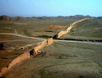
Sanguankou Pass is located 40 km. southwest of Yinchuan city, the provincial capital city of Ningxia Hui Autonomous Region. This pass is at the south end of Helan Shan, the mountain range that separates northwest Ningxia and Inner Mongolia. Historically, Mongolian horsemen crossed this openning on their way south to attack the Central Plains; so the pass has been of great military importance. A quick glance at the map will tell why Sanguankou is strategic: to the west of the pass is the great expanse of the Tenggeli (Tengger) Desert where nothing can stay alive in its midst; so only along the western foot of Helan mountains were towns setup. And along this north and south span of Helan Shan, the Mongolian horsemen came rushing down every hungry winter. Ghengis Klan himself led his cavaliers through Sanguankou, then known as Chimukou, to attack the Western Xia kingdom, whose citizens were so adamant that it took the life of Ghengis to wipe out its last child and flatten its every living space. Today, the only solid proof of this mysterious kingdom's existence is the remains of its royal tombs. These unique cone-shaped tombs dotted the area north of the pass, on the east foot of Helan Shan.
The Great Wall at Sanguankou was constructed during the Ming dynasty (1368-1644), in the tenth year of Jiajing (1531). Nine years later, the Wall was rebuilt again because the earlier Wall was levelled by sandstorms. The new Wall was a composite of local gravels, and imported soil and water. It runs about 80 km. south, across level plains in an almost straight arrow, til it ends not far from the right angle bend of Huang He (Yellow River). Today, a major highway runs through it at the pass, connecting Yinchuan city and Alashanzuoqi in Inner Mongolia.
(Photograph : Qiuyang) |