Official Name:
大河坪山险DaHePingShanXianOur Name:
/
Other Name:
/
Period:明
/ Ming Dynasty 1368~1644
Location: 甘肃省,兰州市,榆中县,起点:来紫堡乡西坪村东5千米的大河坪烽火台止点:来紫堡乡东坪村罗泉湾一社村民张科继的院落北10米 / GanSuSheng,LanZhouShi,YuZhongXian,QiDianLaiZiBaoXiangXiPingCunDong5QianMiDeDaHePingFengHuoTaiZhiDianLaiZiBaoXiangDongPingCunLuoQuanWanYiSheCunMinZhangKeJiDeYuanLuoBei10Mi
[
Looking Local List]
Details:长城类别:墙体
起点经纬高度:东经:104° 02′ 北纬:36° 05′ 海拔:1742
终点经纬高度:东经:104° 01′ 北纬:36° 03′ 海拔:1517
墙体走向:
墙体类别:山险
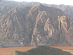
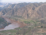
结构特点及构筑方式:利用陡峭的山体,沿山脊穿行,并依托黄河天险,黄河地处桑园子峡内,河道狭窄,蜿蜒曲折,两岸山峦叠嶂,山体坡度较大,坡度一般在300-500左右,海拔在1650米--1750米之间。
山险起自第0102点,止于第0105点,全长3400米。山险沿黄河东岸的大河坪烽火台向黄河上游延伸,经大河坪、罗泉湾山梁至罗泉湾长城起点。这一段黄河河道狭窄,流水湍急,黄河两岸山势陡峭,地形复杂,沟壑纵横,山大沟深,不易穿越。沿线烽火台相连,与自然山体构成防御屏障。
现状:
Type:山险 Precipitous mountain areas
Protection Level:
Content:
Memo:
Other Records:
Distribution:
visit location in Tianditu Map[recommend] Distribution:
visit location in Tencent QQ Map Distribution:
visit location in Google MapDistribution:
visit location in Baidu MapNational ID:620123382106170004
Action:[
 Save in Data Basket
 ]
Picture:
Click the thumbnail to view the Big Pic. Click the Big Pic to Hide the Big Pic![Caption:大河坪山险
loading images --Please wait...]()
![Caption:大河坪山险
loading images --Please wait...]() Photo Links
Photo Links:
 Search ::
  Favorite/My Favorite :: Recent Changes :: :: Login